- Home
- Government
- Departments
- Airport
Airport
 Communities Served
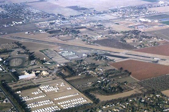
Hanford Municipal Airport is a general aviation facility serving Kings County and the surrounding communities of Hanford, Armona, and Lemoore in south-central California. The airport is located on the southeast edge of the City of Hanford.
The airport is for general aviation and does not offer commercial flights.
Ownership
Hanford Municipal Airport (identifier HJO) is owned and operated by the City of Hanford and is the only publicly owned airport in Kings County.
The airport enforces city, state, and federal aviation regulations, and administers airport leases, tie-downs, hangars, shelters, and their overall maintenance.
Features
Runways
The airport is at approximately 242 feet of elevation with runway locations as follows: Runway 32 is located at latitude 36°18'37.7" North and longitude 119°37'24.5" West. Runway 14 is located at latitude 36°19'22.7" North and longitude 119°37'54.6" West.
Runway 14-32 has increased nearly 3,000 feet from its original length in 1950 to its current (2004) length of 5,180 feet. The runway is 75 feet wide and oriented roughly north-south. The runway is designed to accommodate aircraft with wingspans of up to 79 feet and speeds of up to 121 knots. The runway can accommodate larger aircraft on an occasional basis.
Navigation Technology
Visual landing aids at the airport include Medium Intensity Runway Lights, Precision Approach Path Indicators (PAPI), a rotating beacon, a segmented circle, and a lighted wind cone. The runway offers a straight-in non-precision GPS instrument approach to Runway 32 and a circle-to-land approach to both runway ends. West of the runway, a parallel taxiway and exit taxiways provide connections to the Fixed Base Operator (FBO), aircraft parking/storage areas, and fuel facility.
Parking
Currently, there are 43 transient parking spaces located near the FBO ramp and on the apron areas north and east of the airport manager’s office.
National Weather Service Function
Hanford Municipal Airport also serves as a base for the National Weather Service (NWS), located immediately east of Kings County Fairgrounds. The primary function of the NWS is to provide current and forecasted weather conditions (e.g., humidity, wind speed, barometer, dewpoint, temperature, and visibility).
The airport is equipped with an Automated Surface Observation System (ASOS) that can be reached 24 hours a day at 559-585-8076 to access up-to-the-minute weather information.
Contact Us
For more information about locating your private aircraft at the Hanford Municipal Airport, please contact the airport manager at 559-585-2589.